3D Mapping & 3D Modeling Market Size, Share & Trends Analysis Report By Component (Software, Services), By Type (3D Mapping, 3D Modeling), By Application, By End Use, By Region, And Segment Forecasts, 2025 - 2030
- Report ID: GVR-4-68040-127-4
- Number of Report Pages: 150
- Format: PDF
- Historical Range: 2017 -2024
- Forecast Period: 2025 - 2030
- Industry: Technology
3D Mapping & 3D Modeling Market Trends
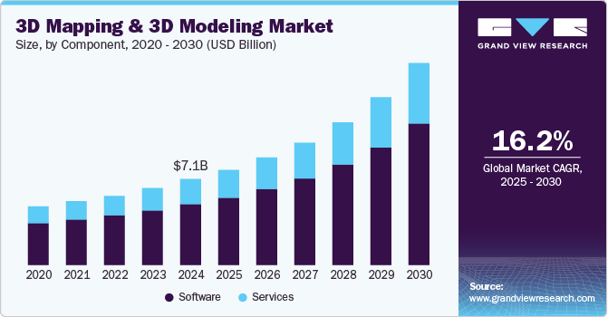
The global 3D mapping & 3D modeling market size was USD 7.12 billion in 2024 and is expected to grow a CAGR of 16.2% from 2025 to 2030. The market's growth is driven by the increasing demand for 3D animation, technological advancements in data acquisition devices such as 3D sensors, the widespread availability of 3D content, and the advent of 3D-enabled display devices. In the construction industry, 3D mapping and modeling are used to create 3D environments, providing a time-efficient method to visualize projects, landscapes, and building sites using computer-generated data.
This technology utilizes machine vision and IoT-enabled devices such as sensors to profile real-world three-dimensional objects, making it a cutting-edge visualization and data collection approach. In the gaming and animation industries, 3D modeling offers numerous advantages, allowing for the creation of immersive environments and lifelike characters. Mobile games and applications increasingly integrate animations to enhance user engagement. For instance, mobile games like "Pokémon GO" utilize spatial models, maps, and animation to bring virtual creatures into the real world through augmented reality (AR).
As augmented reality (AR) and virtual reality (VR) technologies continue to advance, there is an expected increase in demand for intricate spatial models. The focus is anticipated to shift towards real-time and interactive experiences, leveraging powerful GPUs and rendering engines and increasing reliance on artificial intelligence (AI) and procedural generation for generating complex textures and automating tasks in 3D modeling and texturing. Fitness and Health monitoring companies are also investing in 3D modeling technologies. For instance, in January 2023, Strava announced the acquisition of Fatmap, a mapping platform designed for outdoor enthusiasts. This acquisition aims to enhance Strava's offerings for its users who engage in outdoor activities such as hiking, skiing, and mountain biking.
Integrating 3D mapping and modeling solutions with sensor technologies and the Internet of Things (IoT) offers significant advantages and applications across various industries. IoT-enabled devices and sensors collect real-time data from physical objects, equipment, and environments, capturing a wide range of information such as temperature, humidity, pressure, motion, and location. Businesses can continuously gather vast amounts of real-time data by integrating modeling solutions with IoT devices. These solutions are a robust platform for visualizing intricate data from IoT devices, replacing conventional 2D charts and graphs with 3D visualizations that enable users to comprehend data spatially. This allows for more effective identification of patterns, trends, and anomalies.
Businesses can elevate their situational awareness by merging IoT sensor data with 3D mapping and modeling. For instance, in smart cities, sensors can monitor variables like traffic flow, air quality, and waste management. 3D visualizations empower city administrators to make data-driven decisions that optimize city services. The increasing adoption of AR and VR technologies across major industries is augmenting the target market. AR and VR applications heavily rely on 3D mapping for immersive experiences and accurate spatial understanding. This surge in demand for 3D mapping services and solutions is creating new business opportunities and driving growth in the industry as companies seek to enhance user experiences, training, simulation, and visualization in fields such as gaming, healthcare, architecture, and education. Furthermore, 3D mapping platforms, enhanced with VR/AR features, are revolutionizing wayfinding by offering precise, context-rich guidance. For instance, retirement communities employ interactive 3D mapping to assist visitors in touring their facilities, providing real-time progress tracking and AR-based directions. IoT-powered indoor positioning systems, using beacons and Bluetooth technology, also improve indoor navigation, especially in places like airports.
Component Insights
In terms of components, the market is classified into software and services. The software segment held the maximum market share, with a share of 71.2% in 2024. 3D mapping and modeling software are foundational in the industry, providing essential tools for creating, editing, and rendering spatial models and maps across various sectors. Its adaptability makes it valuable to diverse industries, from architecture to healthcare, expanding its customer base significantly. User-friendliness and accessibility have increased over time, attracting both professionals and hobbyists, while ongoing innovations like AI and AR integration drive demand and user engagement. Furthermore, the software's capacity for customization, data integration, collaboration, and cost-effectiveness reinforces its central position in the 3D mapping and modeling ecosystem.
The service segment is expected to emerge as the fastest growing, with a CAGR of 16.8% over the forecast period. The complexity of implementing and utilizing mapping and modeling software that involves spatial dimensions necessitates specialized expertise and technical knowledge, which drives the demand for professional services. Service providers offer customized solutions and support to meet the specific needs of different industries and applications. Services such as training, consulting, and maintenance help users maximize the value and efficiency of their 3D mapping and modeling investments. The continuous advancements in technology and the need for ongoing updates and upgrades contribute to the growth of the services segment in the market.
Type Insights
Based on type, the market has been segmented into 3D mapping, and 3D modeling. The 3D mapping segment is anticipated to witness the highest CAGR of 16.7% over the forecast period. The segment's rapid growth can be attributed to the integration of cutting-edge technologies like LiDAR and photogrammetry, which have significantly improved precision and efficiency in various industries. Governments and organizations increasingly rely on 3D mapping for geospatial applications like urban planning, Geographic Information Systems (GIS), and environmental monitoring. Moreover, worldwide initiatives aimed at creating smarter cities are prompting significant investments in spatial mapping to enhance the efficiency and management of infrastructure and utilities. Disaster management also benefits significantly from real-time 3D mapping data, aiding in terrain assessment and disaster response efforts. In addition, the growing popularity of AR and VR technologies relies heavily on 3D mapping to create immersive digital environments. The rise of navigation and autonomous vehicles, demonstrated by companies like Waymo and Tesla, further emphasizes the critical role of high-quality 3D maps in enhancing safety and efficiency. For instance, in January 2021, HERE, a leading location technology company, unveiled 3D city models tailored for various industries and 3D maps specifically designed for vehicles. These innovations aim to provide a more immersive and accurate mapping experience. The 3D city models offer detailed representations of urban environments, catering to the needs of industries such as architecture, urban planning, and simulation. Meanwhile, the 3D maps for vehicles enhance navigation and location-based services, contributing to improved safety and efficiency in the automotive sector.
The 3D modeling segment held the highest market share of 68.8% in 2024. It caters to industries such as architecture, engineering, construction, gaming, entertainment, and healthcare, making it an essential tool with a wide customer base. The visual appeal of 3D modeling is invaluable for design, simulation, and presentations, further solidifying its market position. 3D modeling is critical for designing and testing aircraft and spacecraft in the aerospace industry. Engineers use these models to simulate aerodynamics, structural integrity, and system functionality, ensuring safe and efficient flight. The demand for immersive content has been a driving force for 3D modeling in these domains. For instance, in May 2022, Ecopia AI revealed an extension of its collaboration with Airbus to combine its 3D vector mapping and modeling capabilities with Airbus' extensive global satellite imaging assets. This collaboration aimed to create highly precise 3D maps of the real world rapidly.
Application Insights
Based on application, the market has been segregated into projection mapping, texture mapping, maps and navigation, and others. The projection mapping segment dominated the overall market, gaining a share of 39.4% in 2024. The rapid growth of the projection mapping segment in the target market is primarily attributed to the rising demand for immersive and visually captivating experiences across various industries, such as events, advertising, entertainment, and architecture. Projection mapping technology, which converts physical surfaces into dynamic and interactive displays, offers new opportunities for storytelling, branding, and artistic expression. As businesses and creators actively seek novel methods to engage and captivate audiences, projection mapping is anticipated to significantly impact the future of visual communication and design. For instance, in June 2022, Buckingham Palace was temporarily transformed into the largest screen using projection mapping in the UK, serving as a dynamic and dramatic backdrop to a live concert commemorating Queen Elizabeth II's 70-year reign.
The maps and navigation segment registered the fastest CAGR of 16.5% over the forecast period. Several factors contribute to this notable growth, including the widespread consumer demand for advanced navigation solutions, particularly on smartphones and GPS-enabled devices. Autonomous vehicles like self-driving cars and delivery drones rely on high-precision 3D maps for safe navigation. Urban planners use detailed 3D maps to optimize city development and smart initiatives amidst rapid urbanization. In logistics and e-commerce, 3D mapping aids in efficient route planning and delivery optimization, reducing costs and environmental impact. Moreover, the tourism and travel industries leverage 3D mapping for immersive experiences and virtual tours of destinations. These applications are fueling the demand for 3D mapping technologies and services. Integrating 3D maps in AR and VR applications has further fueled growth, as has the critical role of 3D maps in route optimization, disaster management, and environmental monitoring. For instance, in January 2023, Luminar announced that it had completed the acquisition of the HD mapping startup Civil Maps. This strategic move provides Luminar with valuable access to Civil Maps' technology, focusing on high-definition mapping and localization. These capabilities are vital in enhancing the safety and functionality of advanced driver assistance systems and vehicle autonomous driving features.
End Use Insights
Based on end use, the market has been segregated intomedia & entertainment, automotive, healthcare, architecture, engineering and construction (AEC), aerospace & defense, logistics, and others. The architecture, engineering, and construction (AEC) segment dominated the overall market, gaining a share of 22.2% in 2024. The segment’s growth can be attributed to its extensive applications, including complex project visualization, collaboration needs, cost and time efficiency, and sustainability considerations. This sector benefits from 3D modeling's ability to facilitate accurate planning, reduce errors, and comply with stringent regulations. 3D modeling aids in visualizing architectural designs, enhancing stakeholder collaboration, and reducing project costs and delays. It also supports sustainability efforts, helping create eco-friendly structures. Further, the surge in construction activities in developing countries such as China, India, South Africa, Brazil, and South Korea, driven by urbanization and infrastructure development, is a significant catalyst for the growth of the target market.
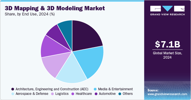
Aerospace & defense registered the fastest CAGR of 16.9% over the forecast period. 3D mapping technologies are recognized for their significant contributions to national security. They assist in military simulations, threat analysis, enhancing preparedness, and crisis response. Furthermore, governments rely on 3D mapping and modeling for large-scale infrastructure projects, disaster management, and border security. Furthermore, spatial mapping & modeling technology in the aerospace industry ensures safe aircraft and spacecraft navigation by providing precise terrain and obstacle information. It aids in mission planning, aircraft design, and testing, enabling complex flight paths and ensuring mission success. The aerospace industry also relies on spatial mapping & modeling for space exploration, military surveillance, satellite imaging, air traffic management, and drone operations. In addition, it supports environmental monitoring efforts, making it a substantial contributor to the target market's growth and development. In counterterrorism, spatial mapping provides insights into urban environments, potential threats, and terrorist hideouts, aiding intelligence gathering and counterterrorism operations. Moreover, law enforcement agencies use mapping for crime scene reconstruction, accident investigation, and crowd management, thus enhancing public safety and law enforcement effectiveness.
Regional Insights
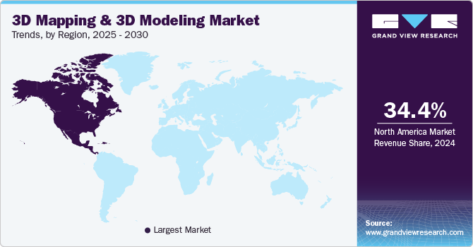
North America dominated the overall market in 2024, with a market share of 34.4%. North America has prominent market players such as Maxar Technologies, Airbus SE, Autodesk, Inc., and Bentley Systems, Incorporated. The North American region is a prominent hub for the target market, driven by its robust technological infrastructure and a growing demand for spatial data solutions. Industries such as urban planning, construction, and entertainment are adopting spatial mapping and modeling for applications like city planning, architectural design, and virtual reality experiences. Government initiatives like smart city projects and infrastructure development further fuel the market's expansion. Furthermore, advancements in LiDAR technology and drone capabilities have accelerated the adoption of 3D mapping for various purposes, including environmental monitoring and disaster management. For instance, in March 2023, Drone Cadets, in partnership with DroneDeploy, undertook an initiative to efficiently map areas affected by the devastating Hurricane Ian of 2022. With more than 100,000 homes suffering damage in this destructive storm, ranked as the fifth strongest to ever strike the U.S., the resulting impact on lives and property was significant. In response, DroneDeploy collaborated with Drone Cadets to support swift relief efforts, generously providing access to its advanced mapping platform for recovery operations.
U.S. 3D Mapping & 3D Modeling Market Trends
The 3D mapping & 3D modeling market in the U.S. is rapidly increasing across various industries due to technological advancements and practical applications. In urban development, for instance, cities like New York use 3D mapping for smart city planning, helping optimize transportation systems and infrastructure. The rise of autonomous vehicles, such as those developed by companies like Waymo, relies heavily on precise 3D maps for navigation.
Asia Pacific 3D Mapping & 3D Modeling Market Trends
The 3D mapping & 3D modeling market in Asia Pacific is expected to witness the highest growth, with a CAGR of 16.9% over the forecast period. Rapid industrialization and urbanization in countries like China and India drive demand for target market solutions across various sectors in the Asia Pacific. In addition, the gaming, entertainment, and automotive industries are leveraging 3D mapping for immersive experiences and product design. Asia Pacific is also witnessing advancements in drone technology, LiDAR applications, and satellite imagery, further fueling the demand for mapping and modeling solutions. Furthermore, government initiatives, such as smart city projects and digital infrastructure development, propel the market's growth. For instance, in September 2022, Bentley Systems, Incorporated, announced a strategic collaboration with Genesys International, a renowned player in advanced mapping and geospatial content services. Under this partnership, Genesys International's pioneering City Digital Twin Solution, tailored for urban India, marks a significant milestone as the country's first city digital twin project. This ambitious endeavor would harness the capabilities of OpenCities 365, Bentley System's infrastructure digital twin solution designed for cities and campuses. The comprehensive mapping and surveying initiative aims to capture extensive data encompassing the urban landscape of India.
Bottom of FormKey 3D Mapping & 3D Modeling Company Insights
Some of the key players operating in the market include Alphabet Inc. and Adobe Inc., among others.
-
Alphabet Inc. is a multinational conglomerate headquartered in California, U.S., and serves as the parent company to Google and other subsidiaries like Waymo, Verily, and DeepMind. In the 3D mapping and modeling sector, Alphabet Inc., through Google, offers advanced 3D mapping and modeling solutions via platforms like Google Earth and Google Maps. These tools provide detailed geographical data, which is enhanced through AI and machine learning for improved accuracy. This technology supports applications in various sectors, including navigation, urban planning, and infrastructure development.
Environmental Systems Research Institute, Inc. (Esri) and Topcon Corporationare some of the emerging market participants in the target market.
-
Topcon Corporation is a Japanese multinational company headquartered in Tokyo, Japan. The company specializes in positioning technologies and providing solutions for the construction, geospatial, and precision agriculture industries. Topcon’s product portfolio includes instruments and software for surveying, machine control systems, and agricultural equipment, helping enhance operational accuracy in various fields. The company focuses on developing technologies that enable automation and data-driven decision-making, particularly in areas like 3D mapping, machine guidance, and precision farming. Topcon serves global markets with its advanced positioning solutions.
Key 3D Mapping & 3D Modeling Companies:
The following are the leading companies in the 3D mapping & 3D modeling market. These companies collectively hold the largest market share and dictate industry trends.
- Maxar Technologies
- Airbus SE
- Autodesk, Inc.
- Bentley Systems, Incorporated.
- Alphabet Inc.
- Trimble Inc.
- Intermap Technologies
- Environmental Systems Research Institute, Inc. (Esri)
- CyberCity 3D, Inc.
- Topcon Corporation
- Dassault Systèmes
- Adobe Inc.
- Pix4D SA
- Pixologic, Inc.
- Maxon Computer GmbH
Recent Developments
-
In September 2024, Adobe Inc. announced upgrades to Adobe After Effects, focusing on enhancing 3D motion design capabilities. Key updates include a revamped 3D workspace, improved rendering speed, and the introduction of new tools that streamline the animation process. These enhancements aim to simplify the integration of 3D elements into motion graphics, enabling users to create more complex and visually appealing animations with greater ease. The updated software supports a more intuitive interface, allowing seamless interaction between 2D and 3D design elements.
-
In January 2024, Alphabet Inc. introduced significant updates to Google Maps aimed at enhancing the user experience, particularly for mobile navigation and Android Auto. A notable feature is the new 3D building display, which allows users to view three-dimensional representations of buildings during navigation. This addition improves the overall navigation experience by providing clearer visual cues and enhanced zoom capabilities.
3D Mapping & 3D Modeling Market Report Scope
|
Report Attribute |
Details |
|
Market size value in 2025 |
USD 7.93 billion |
|
Revenue forecast in 2030 |
USD 16.78 billion |
|
Growth rate |
CAGR of 16.2% from 2025 to 2030 |
|
Actual data |
2017 - 2024 |
|
Forecast period |
2025 - 2030 |
|
Quantitative units |
Revenue in USD million/billion and CAGR from 2025 to 2030 |
|
Report coverage |
Revenue forecast, company ranking, competitive landscape, growth factors, and trends |
|
Segments covered |
Component, type, application, end use, region |
|
Regional scope |
North America; Europe; Asia Pacific; Latin America; MEA |
|
Country scope |
U.S.; Canada; UK; Germany; France; China; India; Japan; South Korea; Australia; Brazil; Mexico; Kingdom of Saudi Arabia (KSA); UAE; South Africa |
|
Key companies profiled |
Maxar Technologies; Airbus SE; Autodesk, Inc.; Bentley Systems, Incorporated.; Alphabet Inc.; Trimble Inc.; Intermap Technologies; Environmental Systems Research Institute, Inc. (Esri); CyberCity 3D, Inc.; Topcon Corporation; Dassault Systèmes; Adobe Inc.; Pix4D SA; Pixologic, Inc.; Maxon Computer GmbH. |
|
Customization scope |
Free report customization (equivalent up to 8 analysts working days) with purchase. Addition or alteration to country, regional & segment scope. |
|
Pricing and purchase options |
Avail customized purchase options to meet your exact research needs. Explore purchase options |
Global 3D Mapping & 3D Modeling Market Report Segmentation
This report forecasts revenue growth at the global, regional, and country levels and provides an analysis of the latest trends and opportunities in each of the sub-segments over the forecast period. For this study, Grand View Research has segmented the global 3D mapping & 3D modeling market based on component, type, application, end use, and regions:
-
Component Outlook (Revenue, USD Million, 2017 - 2030)
-
Software
-
Services
-
-
Type Outlook (Revenue, USD Million, 2017 - 2030)
-
3D Mapping
-
3D Modeling
-
-
Application Outlook (Revenue, USD Million, 2017 - 2030)
-
Projection Mapping
-
Texture Mapping
-
Maps and Navigation
-
Others
-
-
End Use Outlook (Revenue, USD Million, 2017 - 2030)
-
Media & Entertainment
-
Automotive
-
Healthcare
-
Architecture, Engineering and Construction (AEC)
-
Aerospace & Defense
-
Logistics
-
Others
-
-
Regional Outlook (Revenue, USD Million, 2017 - 2030)
-
North America
-
U.S.
-
Canada
-
-
Europe
-
UK
-
Germany
-
France
-
-
Asia Pacific
-
China
-
India
-
Japan
-
South Korea
-
Australia
-
-
Latin America
-
Brazil
-
Mexico
-
-
Middle East and Africa (MEA)
-
Kingdom of Saudi Arabia (KSA)
-
UAE
-
South Africa
-
-
Frequently Asked Questions About This Report
b. The global 3D mapping & 3D modeling market size was estimated at USD 7.12 billion in 2024 and is expected to reach USD 7.93 billion in 2025.
b. The global 3D mapping & 3D modeling market is expected to witness a compound annual growth rate of 16.2% from 2025 to 2030 to reach USD 16.78 billion by 2030.
b. North America dominated the overall market in 2024, with a market share of 34.4%, owing to significant government initiatives, such as smart city projects and infrastructure development.
b. Some prominent players in the market include Maxar Technologies; Airbus SE; Autodesk, Inc.; Bentley Systems, Incorporated.; Alphabet Inc.; Trimble Inc.; Intermap Technologies; Environmental Systems Research Institute, Inc. (Esri); CyberCity 3D, Inc.; Topcon Corporation; Dassault Systèmes; Adobe Inc.; Pix4D SA; Pixologic, Inc.; and Maxon Computer GmbH, among others.
b. The growth of the 3D mapping & 3D modeling market is driven by the increasing demand for 3D animation, technological advancements in data acquisition devices such as 3D sensors, the widespread availability of 3D content, and the advent of 3D-enabled display devices.
We are committed towards customer satisfaction, and quality service.
"The quality of research they have done for us has been excellent."

